Credit: NASA JPL PO.DAAC.
Animation: Multi-Mission Optimally Interpolated Sea Surface Salinity Monthly L4 Global Dataset V1
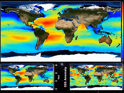
[22-Feb-2022] Animation of the Multi-Mission Optimally Interpolated Sea Surface Salinity (OISSS) monthly level 4
global dataset based on the AQUARIUS/SAC-D, SMAP and SMOS level 2 mission data gridded on a 0.25 degree spatial
grid with a monthly time scale. The dataset covers the period from September 2011 to the August 2021, and is
produced at the International Pacific Research Center (IPRC) of the University of Hawaii at Manoa in collaboration
with the Remote Sensing Systems (RSS), Santa Rosa, California. Read more
here.
Animation:
Multi-Mission Optimally Interpolated Sea Surface Salinity Monthly L4 Global
Dataset V1 | PO.DAAC / JPL / NASA
(00:02:05) Credit: NASA JPL PO.DAAC.
YouTube »

