Credit: NASA JPL PO.DAAC.
Saildrone ATOMIC Field Campaign Along-track Measurement Data - SST and SSS Observations (SD1026)
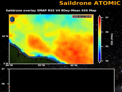
[30-Jul-2020] Animation showing the survey track and measurement data for the NASA-contracted saildrone SD1026 deployed during the ATOMIC field campaign over a 45 day period from 17 January 2020 to 2 March 2020 in the Caribbean region. Here we see time series of sea surface salinity (SSS) and sea surface temperature (SST) measurements in relation to satellite SSS and SST respectively. The animation also maps the movement of the saildrone, with colors representing collocated satellite SSS and SST along-track. The dataset can be accessed from the
PO.DAAC Portal. DOI: 10.5067/SDRON-ATOM0. (00:02:30) Credit: NASA JPL PO.DAAC.
YouTube »

