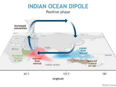
Credit: NOAA Climate.gov.
Indian Ocean Dipole Positive Phase
[27-Feb-2020] The recent bushfires in Australia have left a trail of destruction, gripping the world with infernal images of widespread devastation. The catastrophic bushfire season resulted from extremely hot and dry weather in spring and early summer throughout the country. As is usually the case, such extreme conditions involve several factors working together, including human-caused global warming as well as naturally occurring weather and climate patterns. One of those important factors was an extreme Indian Ocean Dipole (IOD) event.
During the positive phase of the Indian Ocean Dipole, which typically peaks in September - November, cooler-than-normal sea surface conditions west of Indonesia and warmer-than-normal conditions in the western Indian Ocean alter the atmospheric circulation in the Indian Ocean region. Indonesia and Australia tend to be drier than normal, which increases the chances of bushfires, while eastern Africa tends to be wetter than normal, increasing the likelihood of floods. The negative phase brings the opposite pattern.
View: Click on the image to enlarge. Click on the Escape key or anywhere outside the shadowbox to close.
Download: To download a copy, right click on the image and select Save Image As (on a Mac keyboard, click the touchpad while holding down the Control key). To download the highest resolution in our database, first click on the image to enlarge and then save that version.